
Claire Kelly, a senior planner at environmental consultants Boffa Miskell, based in Christchurch, suggests a national policy statement or a dedicated chapter in each regional policy statement setting out the requirements for safeguarding of both aggregate and rock reserves.
Reality: Quarrying for aggregate and rock is a necessity; without it, there would be no sea walls, roads, foundations for buildings, bridges, wastewater treatment plants, or other necessary buildings and structures.
Unless we are all happy to pay a lot more for our critical infrastructure and way of life, we also need to recognise the cost of transporting material. As the industry understands, quarries need to be relatively close to their markets. Despite this reality, protecting our current reserves1 and consenting new quarries or expansions to existing quarries is unnecessarily difficult.
This is not a new problem.
In 2000, Paul Swain, then Associate Minister of Energy, spoke at the Institute of Quarrying and Aggregates and Quarries Association Conference and appeared to offer some hope. He acknowledged that the: “Quarry and aggregates industry has long been the cornerstone of New Zealand society providing industrial rocks for concrete, road making and building and fertiliser application.
“However, the industry suffers from a poor image among parts of the population and there is some frustration in the industry about the differing applications of the Resource Management Act by local councils. The Ministry for the Environment intends putting together some good practice models for use by councils. These good practice models will look at good ways of writing rules and approaching RMA issues.”2
Twenty-five years on, and still we wait. Quarry operators have to navigate different pieces of legislation, such as the Crown Minerals Act, the Wildlife Act, and the Resource Management Act with its numerous layers of national environmental standards, regional policy statements, regional plans, and district plans.
The Government is replacing the RMA, but I will focus on protecting and managing our aggregate and rock reserves within existing quarries and beyond.
Some district plans zone or provide an overlay to ‘protect’ consented or established quarries or areas granted for expansion, but not the reserve. So, this approach does not address the issue of establishing new quarries and the underlying value of the resource to communities.
The industry is also subject to greater scrutiny and more stringent controls, especially (in Canterbury at least) regarding the management of the effects of dust on human health – a regional council matter – and this can trigger limited or even full public notification.
The generation of high volumes of trucks on rural roads and changes to existing rural character and amenities (district council matters) also often trigger some type of notification.
Some district plans contain rules restricting residential development near an established quarry or quarry zone, but consent can be sought to reduce any identified setback. This also misses the bigger picture of development encroaching over large areas, constraining future expansions and new quarries (see west of Christchurch, where rural-lifestyle developments have slowly extended out from the edges of the city) and lock up land that contains quarry reserves. It also does not address the time and money quarry operators spend opposing encroaching development.
Over the years, local councils have attempted to address industry concerns. For example, in preparing its Proposed Replacement District Plan in 2013, Christchurch City Council (CCC) contemplated a more enabling policy approach combined with the potential to make more efficient use of existing reserves (e.g. an ability to excavate deeper and reduced setbacks) as an efficient and effective means of enabling greater aggregate supply.
This was critical as Christchurch and its surrounds recovered from the 2010-2011 earthquakes. However, the proposed planning strategy set before the Hearing Panel sought to retain unchanged, many of the former plans’ performance standards, mainly because they were developed after previous significant public processes and because significant amendments would essentially be ineffective given the longstanding existing uses in the Rural Quarry Zone.
To be fair, the CCC was under pressure to deliver a district plan to support the recovery process within a timeframe set by the government. Interestingly, CCC did not support the extension of the Rural Quarry Zone because, among other reasons, it favoured a consenting rather than a zoning approach, to enable a broader range and more site-specific effects to be addressed.
Earlier in the process, the CCC proposed including an appendix and planning map overlay in the Proposed Plan that identified an area where high-quality gravels are known to exist in the District.
Its primary purpose was to give the public an indication of where quarries might be established as discretionary activities. A secondary purpose was as a tool to consider the potential adverse effects of further land fragmentation and intensification of sensitive land uses on aggregate reserves. The Hearings Panel removed these provisions as it considered they caused public confusion and were seen as encouraging the establishment of quarries in the area. The industry thought the related provisions needed strengthening to give them greater effect and, again, time was against everyone.
Fast forward to 2024, and GNS Science has built a spatial model of the critical components of aggregate opportunity using digitally accessible geological, land use, statistical and geographic data. Model components included source rocks, land use, future demand, supporting infrastructure and cultural sensitivity in 23 mappable criteria layers. GNS presented this at the QuarryNZ Conference last year in Rotorua.
But what is the point of knowing where aggregate, or even rock, is, if you can’t protect it for future use? I understand that this has been an industry conversation for a long time, with a concern that identifying areas of reserves could drive up land prices. Then there is the question of the relative quality of the aggregate or rock. The only way to get a truly accurate picture is by drilling and bore logs, but if the reserve is covered in houses, this point is moot.
I think that, given sufficient time, the right level of engagement with communities, including iwi, and supporting plan rules, the information generated by GNS Science and others could form the basis of mapping and protecting quarry reserves in district plans, something loosely based on the UK planning system.
A proposal loosely based on the UK planning system
In my view, we need a national policy statement or a dedicated chapter in each regional policy statement setting out the requirements for safeguarding aggregate and rock reserves.
For example, direct the regional councils to work with the district councils and the quarry industry (this would need to be a representative industry group) to plan for the steady and adequate supply of aggregate and rock by identifying the following:
All existing active areas i.e. consented or long-established quarries operating under existing use rights. These are often zoned but should have significant buffer areas, within which either development requires consent, or the quarry is notified of all applications.
Quarrying Safeguarding Areas (QSAs) are based on the UK Minerals Safeguarding Areas (MSAs) that include areas of known reserves (spatial planning).
Providing direction on how to manage and/or protect minerals or rock in QSAs i.e. directing that territorial authorities should not normally permit other development proposals in QSAs if they might constrain potential future use for extraction and processing activities.
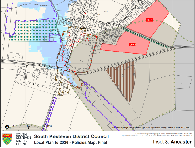
A helpful option available to territorial local authorities is the identification of QSA’s on planning maps, as per the example of an MSA (illustration on page 27) from the South Kesteven District Council Local Plan (located within the United Kingdom)3. The brown striped area is an active quarry, and the grey area around it, edged with green triangles, is an MSA. If councils were to implement such an approach through their District Plans, they would need to do the following:
Address potential ‘conflicts’ i.e. where a QSA would overlap an outstanding natural landscape (ONL) or area with outstanding natural character (ONC), and/or significant natural area (SNA). While a quarry in an ONL or ONC is unlikely to be palatable to many, a quarry can (and does) operate around SNAs with opportunities for rehabilitation to create ecological corridors.
Set out policies and enable rules to manage extraction and processing within QSAs.
Adopt clear management policies which set out how proposals for non-minerals development in QSAs will be handled, and what action applicants for development should take to address the risk of losing the ability to extract the reserve. This may include policies that encourage the prior extraction of material where practicable, if it is necessary for non-mineral development to occur in QSAs and to prevent the unnecessary sterilisation of aggregate or rock reserves.
Potentially allocate sites for non-minerals development within QSAs with rules to manage that development (spatial planning).
Potentially prohibiting certain types of development that would be sensitive to quarry activities.
Require Quarrying Assessments to support non-quarrying development in QSAs. Mineral Assessments could be used to show the viability of a reserve, including information on the reserve’s physical characteristics and site settings, such as the observation of water depths and grading analysis of the natural geology.
This approach aims to minimise the risk of reverse sensitivity effects and development that encroaches upon and limits future quarrying activities.
After all, the houses impinging on quarries or being built over reserves require aggregate construction. This needs to be recognised more explicitly in plans, in the same manner as we protect rural land for primary production and set back residential properties from intensive agriculture.
The quarry industry has improved its environmental performance over the past 20 years and more. Yes, dust escapes beyond the boundary on occasion, but let us try living without aggregate and rock.
Claire obtained her academic qualifications in the United Kingdom, has 19 years’ experience practising as a consultant planner in New Zealand and has worked extensively with the quarrying industry. The opinions expressed in this article are solely her own and do not necessarily reflect the views of her employer Boffa Miskell.
FOOTNOTES
1. I have focused on reserves that can be readily extracted and are economically viable rather than the wider resource.
2. https://www.beehive.govt.nz/speech/institute-quarrying-and-aggregates-and-quarries-association-conference
3. https://www.southkesteven.gov.uk/sites/default/files/2023-08/Inset_3_-_Ancaster.pdf